Fergana Valley: Why Central Asia Has the World's Worst Borders
Quick Summary
Why does Central Asia have the most chaotic borders on Earth? The Fergana Valley's border gore has deep Soviet roots — and still fuels conflict today.
In This Article
The Valley That Broke Every Rule of Modern Borders
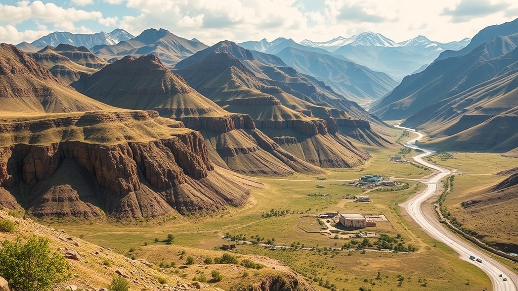
Most people, when they think about badly drawn borders, picture Africa — straight lines sliced by colonial rulers who had never set foot on the continent. But the most cartographically chaotic borders on Earth aren't in Africa. They're in a fertile valley wedged between mountain ranges in the heart of Central Asia, and they make Africa's colonial-era lines look tidy by comparison.

The Fergana Valley — home to roughly 17 million people, representing about one in five of all Central Asia's inhabitants — is divided between Uzbekistan, Kyrgyzstan, and Tajikistan in a way that defies rational explanation at first glance. Borders zigzag. Territory folds back on itself. Countries have fingers of land connected to their mainlands by corridors barely 360 metres wide. And scattered across the valley like dropped puzzle pieces are no fewer than eight fully isolated exclaves — patches of one country's sovereign territory completely surrounded by another country's land.
This isn't an accident. It isn't laziness. And it isn't simply the result of colonial indifference. The story of why these borders exist is one of the most revealing case studies in how ideology, ethnography, geopolitics, and sheer human complexity collide — and why the consequences of getting borders wrong don't fade with time. They fester.
What Life Actually Looks Like Inside These Borders
Before unpacking the history, it's worth understanding the human cost of what these lines on a map mean in practice — because this isn't just an academic curiosity.
Take the Tajik exclave of Vorukh. Entirely surrounded by Kyrgyzstan, with no physical connection to mainland Tajikistan, Vorukh is home to approximately 45,000 people who are effectively marooned. They can't travel to their own country without crossing another country's territory. Trade is restricted. Infrastructure investment is minimal. Economic development is nearly impossible when your supply chains run through a neighbour that disputes your right to exist where you are.
Tajikistan has historically argued that Vorukh should be connected to the mainland by a land corridor — a claim that Kyrgyzstan fiercely rejects because that corridor would cut through internationally recognised Kyrgyz territory. The dispute has led to multiple armed clashes in recent decades, including serious violence in 2021 that killed dozens and displaced thousands. People died over a border drawn by Soviet bureaucrats a century ago.
Then there's the So District — a large Uzbek exclave entirely surrounded by Kyrgyzstan and home to around 80,000 people, the vast majority of whom are ethnic Tajiks. So this is Uzbek sovereign territory, surrounded by Kyrgyzstan, populated by Tajiks. It is a geopolitical triple-layer paradox that would be almost funny if real people's lives weren't built on top of it.
The Pre-Soviet Fergana Valley: A World Without Ethnic Labels
To understand why these borders are so convoluted, you have to understand what the Fergana Valley was before anyone tried to draw lines through it. And the answer, in short, is: deeply, organically complex.
The valley sits at a geographic sweet spot — a lush, agriculturally rich oasis roughly the size of New Jersey, surrounded on most sides by mountains, fed by glacial rivers, and positioned directly on the ancient Silk Road. For millennia it was a crossroads of empires — Greek, Persian, Mongol, Chinese, Timurid, and eventually Russian — each leaving behind linguistic, cultural, and genetic traces in the population.
By the early 19th century, the valley was broadly unified under the Khanate of Kokand and contained a richly layered society. Persian-speaking and Turkic-speaking sedentary farmers — collectively called Sarts — lived intermingled in the cities and lowlands. Nomadic Turko-Mongol tribes occupied the surrounding mountains and grasslands, frequently raiding, settling, and intermarrying with the sedentary populations.
Critically, none of these people identified primarily through the lens of ethnicity as we understand it today. Identity was organised around tribe, clan, religion (predominantly Islam), and the fundamental divide between sedentary and nomadic life. People routinely spoke multiple languages. Mixed ancestry was the norm, not the exception. The concept of being definitively and exclusively 'Uzbek' or 'Kyrgyz' or 'Tajik' simply didn't exist in any meaningful political sense.
When the Tsarist Russian Empire absorbed Central Asia between the 1850s and 1870s, it broadly left this complexity alone, governing the region as a loose colonial administration without attempting to impose ethnic categories on the population. That relatively hands-off approach was about to change dramatically.
Stalin's Census, Soviet Ideology, and the Impossibility of Clean Lines
After the October Revolution of 1917, the Bolsheviks inherited both Central Asia and a serious problem: the Basmachi movement, a pan-Turkic, pan-Islamic insurgency that had begun in the Fergana Valley following Tsarist conscription policies and exploded into full-scale guerrilla warfare. The Red Army's brutal suppression — including a massacre of up to 25,000 people in Kokand in 1918 — prolonged the conflict rather than ending it. It took until 1923 to largely pacify the valley, at enormous cost.
The Soviets drew a clear lesson: unified pan-Turkic or pan-Islamic identity in Central Asia was dangerous. Their solution was to encourage the development of distinct, separate national identities — Uzbek, Kyrgyz, Tajik, Kazakh, Turkmen — that would divide the region along national rather than religious or civilisational lines, making another unified revolt far less likely.
This is what drove the National Delimitation of Soviet Central Asia, which began formally in 1924 with Joseph Stalin serving as People's Commissar of Nationalities. The plan was to create Soviet Socialist Republics (SSRs) built around distinct ethnic groups, each as demographically homogeneous as possible.
The problem was that the Fergana Valley made this essentially impossible.
The census conducted to inform the border-drawing process was an almost heroic exercise in futility. Census takers had to travel on horseback from door to door — and up to 60% of Kyrgyz and Kazakh communities were still nomadic and had no doors. When enumerators did reach settled communities, they frequently encountered people who spoke three languages, had parents of different ethnicities, and had never been asked — or needed — to pick just one identity. There are documented accounts of frustrated Soviet ethnographers demanding that families choose a single nationality, only to watch different members of the same household choose different ones.
The borders that emerged from this process reflect exactly that impossibility. Cities with majority Tajik-speaking populations — like Bukhara and Samarkand — ended up inside Uzbekistan because they were surrounded by Turkic-speaking countryside and the Soviets wanted contiguous territory. Cities like Osh and Jalal-Abad, located inside what became Kyrgyzstan, had majority Uzbek populations because nomadic Kyrgyz didn't tend to congregate in urban centres. Economic viability requirements — each SSR needed at least a million people, rail access to a capital, and a fair share of water resources — frequently overrode demographic logic entirely.
And then there were the exclaves. In many cases these were the result of local officials bribing or negotiating to have their home villages included in a particular republic for personal or clan reasons, regardless of ethnic composition. The borders were never intended to be international frontiers. Nobody drawing them in 1924 seriously envisioned a world in which the Soviet Union would dissolve and these administrative lines would suddenly become hard national borders with customs posts and armed guards.
That world arrived in 1991.
Why the Borders Haven't Been Fixed — and Probably Won't Be
The obvious question is: why not just redraw them? The borders are clearly dysfunctional. Everyone involved knows they are dysfunctional. International organisations have spent decades trying to facilitate negotiations. So why do they persist?
The answer comes down to a convergence of factors that each make change individually difficult, and collectively make it nearly impossible.
Sovereignty is zero-sum. Any territorial adjustment that benefits one country comes at the direct expense of another. Kyrgyzstan granting Tajikistan a land corridor to Vorukh means Kyrgyzstan loses sovereign territory. There is no version of that negotiation where Kyrgyzstan gains anything tangible in return, which makes it extraordinarily difficult to sell domestically.
Ethnic grievances run deep in multiple directions. Uzbekistan has significant Tajik-speaking minorities. Tajikistan has significant Uzbek-speaking communities. Kyrgyzstan's Uzbek minority, concentrated in the south near the Fergana Valley, was the target of serious ethnic violence as recently as 2010, when inter-communal clashes killed hundreds. These wounds don't heal quickly, and border renegotiations inevitably reopen them.
Water is existential. The Fergana Valley's rivers — the Syr Darya and Kara Darya — are the lifeblood of the entire region's agriculture. Control over water access is deeply tied to border configuration. Any border adjustment touches water rights, and water disputes in a region facing increasing climate stress are not disputes anyone takes lightly.
Free Weekly Newsletter
Enjoying this guide?
Get the best articles like this one delivered to your inbox every week. No spam.
Precedent cuts both ways. If one exclave's status is renegotiated, every other disputed territory becomes a legitimate subject for reopening. No government wants to establish that precedent.
The result is a region where the borders are universally acknowledged as irrational, where the conflicts they generate are ongoing and sometimes lethal, and where no party has sufficient incentive to make the concessions that resolution would require.
What the Fergana Valley Teaches Us About Drawing Borders
The Fergana Valley is an extreme case, but it isn't a unique one. From the Balkans to the Caucasus to the Middle East, the 20th century is littered with examples of borders drawn through complex, multilingual, multi-ethnic societies by outside powers who applied neat categorical frameworks to inherently messy human realities.
The Soviet experiment in Central Asia is particularly instructive because it was genuinely well-intentioned in its methodology, at least in part. The ethnographic surveys were real. The census was attempted. The effort to align political units with demographic reality was sincere — even if it was also instrumentalised for strategic purposes. And it still produced borders that have fuelled conflict for over a century.
The lesson isn't that borders shouldn't follow demographic lines. It's that when human identity is genuinely complex — when people's sense of self crosses multiple linguistic, cultural, and ancestral categories simultaneously — there may be no clean line to draw. The Soviets tried to impose clarity on complexity. The complexity won.
For the 17 million people living in the Fergana Valley today, the consequences of that failed imposition are not historical footnotes. They are the reality of everyday life: checkpoints on roads that should be open, relatives living in technically foreign territory, water rights that hinge on borders that made no sense when they were drawn and make less sense now.
The Fergana Valley's border gore isn't just a cartographic curiosity. It's a warning about what happens when the map refuses to match the territory — and nobody has the courage or the incentive to redraw it.
Frequently Asked Questions
What is the Fergana Valley and why is it significant?
The Fergana Valley is a densely populated agricultural region in Central Asia, roughly the size of New Jersey, divided between Uzbekistan, Kyrgyzstan, and Tajikistan. It's home to approximately 17 million people — about one in five of all Central Asia's population — and sits at a historic Silk Road crossroads. It's geopolitically significant today because it contains some of the most complex and conflict-prone borders in the world, including multiple international exclaves.
What is an exclave and how many are there in the Fergana Valley region?
An exclave is a portion of a country's territory that is completely surrounded by the territory of another country, with no land connection to the main body of the nation. The Fergana Valley region contains at least eight internationally recognised exclaves: four belonging to Uzbekistan, two to Tajikistan, and one to Kyrgyzstan, among others. The most notable are the Tajik exclave of Vorukh and the Uzbek So District, both surrounded by Kyrgyzstan.
Did Stalin deliberately create the chaotic borders of Central Asia?
This is genuinely debated by historians. The 'divide and rule' interpretation argues Stalin drew the borders to be deliberately messy, ensuring the republics would remain dependent on Moscow and unable to unify against Soviet authority. But the counterargument is compelling too: the demographic reality of the Fergana Valley — with its deeply intermingled, multi-ethnic, multilingual population that largely lacked clear ethnic self-identification — made clean borders virtually impossible for anyone to draw, regardless of intent. Both things can be partially true simultaneously.
Why haven't the borders been renegotiated or fixed since Soviet collapse?
Multiple factors prevent resolution. Any border change is zero-sum — what one country gains, another loses, with no obvious compensation. Ethnic tensions between Uzbek, Kyrgyz, and Tajik communities remain raw, with serious violence as recently as 2010 and 2021. Control over water resources is closely tied to border configuration in an increasingly water-stressed region. And any renegotiation of one territory risks opening every other disputed area to challenge. The result is a political stalemate that prioritises the status quo over functional geography.
Frequently Asked Questions
The Valley That Broke Every Rule of Modern Borders
Most people, when they think about badly drawn borders, picture Africa — straight lines sliced by colonial rulers who had never set foot on the continent. But the most cartographically chaotic borders on Earth aren't in Africa. They're in a fertile valley wedged between mountain ranges in the heart of Central Asia, and they make Africa's colonial-era lines look tidy by comparison.
The Fergana Valley — home to roughly 17 million people, representing about one in five of all Central Asia's inhabitants — is divided between Uzbekistan, Kyrgyzstan, and Tajikistan in a way that defies rational explanation at first glance. Borders zigzag. Territory folds back on itself. Countries have fingers of land connected to their mainlands by corridors barely 360 metres wide. And scattered across the valley like dropped puzzle pieces are no fewer than eight fully isolated exclaves — patches of one country's sovereign territory completely surrounded by another country's land.
This isn't an accident. It isn't laziness. And it isn't simply the result of colonial indifference. The story of why these borders exist is one of the most revealing case studies in how ideology, ethnography, geopolitics, and sheer human complexity collide — and why the consequences of getting borders wrong don't fade with time. They fester.
What Life Actually Looks Like Inside These Borders
Before unpacking the history, it's worth understanding the human cost of what these lines on a map mean in practice — because this isn't just an academic curiosity.
Take the Tajik exclave of Vorukh. Entirely surrounded by Kyrgyzstan, with no physical connection to mainland Tajikistan, Vorukh is home to approximately 45,000 people who are effectively marooned. They can't travel to their own country without crossing another country's territory. Trade is restricted. Infrastructure investment is minimal. Economic development is nearly impossible when your supply chains run through a neighbour that disputes your right to exist where you are.
Tajikistan has historically argued that Vorukh should be connected to the mainland by a land corridor — a claim that Kyrgyzstan fiercely rejects because that corridor would cut through internationally recognised Kyrgyz territory. The dispute has led to multiple armed clashes in recent decades, including serious violence in 2021 that killed dozens and displaced thousands. People died over a border drawn by Soviet bureaucrats a century ago.
Then there's the So District — a large Uzbek exclave entirely surrounded by Kyrgyzstan and home to around 80,000 people, the vast majority of whom are ethnic Tajiks. So this is Uzbek sovereign territory, surrounded by Kyrgyzstan, populated by Tajiks. It is a geopolitical triple-layer paradox that would be almost funny if real people's lives weren't built on top of it.
The Pre-Soviet Fergana Valley: A World Without Ethnic Labels
To understand why these borders are so convoluted, you have to understand what the Fergana Valley was before anyone tried to draw lines through it. And the answer, in short, is: deeply, organically complex.
The valley sits at a geographic sweet spot — a lush, agriculturally rich oasis roughly the size of New Jersey, surrounded on most sides by mountains, fed by glacial rivers, and positioned directly on the ancient Silk Road. For millennia it was a crossroads of empires — Greek, Persian, Mongol, Chinese, Timurid, and eventually Russian — each leaving behind linguistic, cultural, and genetic traces in the population.
By the early 19th century, the valley was broadly unified under the Khanate of Kokand and contained a richly layered society. Persian-speaking and Turkic-speaking sedentary farmers — collectively called Sarts — lived intermingled in the cities and lowlands. Nomadic Turko-Mongol tribes occupied the surrounding mountains and grasslands, frequently raiding, settling, and intermarrying with the sedentary populations.
Critically, none of these people identified primarily through the lens of ethnicity as we understand it today. Identity was organised around tribe, clan, religion (predominantly Islam), and the fundamental divide between sedentary and nomadic life. People routinely spoke multiple languages. Mixed ancestry was the norm, not the exception. The concept of being definitively and exclusively 'Uzbek' or 'Kyrgyz' or 'Tajik' simply didn't exist in any meaningful political sense.
When the Tsarist Russian Empire absorbed Central Asia between the 1850s and 1870s, it broadly left this complexity alone, governing the region as a loose colonial administration without attempting to impose ethnic categories on the population. That relatively hands-off approach was about to change dramatically.
Stalin's Census, Soviet Ideology, and the Impossibility of Clean Lines
After the October Revolution of 1917, the Bolsheviks inherited both Central Asia and a serious problem: the Basmachi movement, a pan-Turkic, pan-Islamic insurgency that had begun in the Fergana Valley following Tsarist conscription policies and exploded into full-scale guerrilla warfare. The Red Army's brutal suppression — including a massacre of up to 25,000 people in Kokand in 1918 — prolonged the conflict rather than ending it. It took until 1923 to largely pacify the valley, at enormous cost.
The Soviets drew a clear lesson: unified pan-Turkic or pan-Islamic identity in Central Asia was dangerous. Their solution was to encourage the development of distinct, separate national identities — Uzbek, Kyrgyz, Tajik, Kazakh, Turkmen — that would divide the region along national rather than religious or civilisational lines, making another unified revolt far less likely.
This is what drove the National Delimitation of Soviet Central Asia, which began formally in 1924 with Joseph Stalin serving as People's Commissar of Nationalities. The plan was to create Soviet Socialist Republics (SSRs) built around distinct ethnic groups, each as demographically homogeneous as possible.
The problem was that the Fergana Valley made this essentially impossible.
The census conducted to inform the border-drawing process was an almost heroic exercise in futility. Census takers had to travel on horseback from door to door — and up to 60% of Kyrgyz and Kazakh communities were still nomadic and had no doors. When enumerators did reach settled communities, they frequently encountered people who spoke three languages, had parents of different ethnicities, and had never been asked — or needed — to pick just one identity. There are documented accounts of frustrated Soviet ethnographers demanding that families choose a single nationality, only to watch different members of the same household choose different ones.
The borders that emerged from this process reflect exactly that impossibility. Cities with majority Tajik-speaking populations — like Bukhara and Samarkand — ended up inside Uzbekistan because they were surrounded by Turkic-speaking countryside and the Soviets wanted contiguous territory. Cities like Osh and Jalal-Abad, located inside what became Kyrgyzstan, had majority Uzbek populations because nomadic Kyrgyz didn't tend to congregate in urban centres. Economic viability requirements — each SSR needed at least a million people, rail access to a capital, and a fair share of water resources — frequently overrode demographic logic entirely.
And then there were the exclaves. In many cases these were the result of local officials bribing or negotiating to have their home villages included in a particular republic for personal or clan reasons, regardless of ethnic composition. The borders were never intended to be international frontiers. Nobody drawing them in 1924 seriously envisioned a world in which the Soviet Union would dissolve and these administrative lines would suddenly become hard national borders with customs posts and armed guards.
That world arrived in 1991.
Why the Borders Haven't Been Fixed — and Probably Won't Be
The obvious question is: why not just redraw them? The borders are clearly dysfunctional. Everyone involved knows they are dysfunctional. International organisations have spent decades trying to facilitate negotiations. So why do they persist?
The answer comes down to a convergence of factors that each make change individually difficult, and collectively make it nearly impossible.
Sovereignty is zero-sum. Any territorial adjustment that benefits one country comes at the direct expense of another. Kyrgyzstan granting Tajikistan a land corridor to Vorukh means Kyrgyzstan loses sovereign territory. There is no version of that negotiation where Kyrgyzstan gains anything tangible in return, which makes it extraordinarily difficult to sell domestically.
Ethnic grievances run deep in multiple directions. Uzbekistan has significant Tajik-speaking minorities. Tajikistan has significant Uzbek-speaking communities. Kyrgyzstan's Uzbek minority, concentrated in the south near the Fergana Valley, was the target of serious ethnic violence as recently as 2010, when inter-communal clashes killed hundreds. These wounds don't heal quickly, and border renegotiations inevitably reopen them.
Water is existential. The Fergana Valley's rivers — the Syr Darya and Kara Darya — are the lifeblood of the entire region's agriculture. Control over water access is deeply tied to border configuration. Any border adjustment touches water rights, and water disputes in a region facing increasing climate stress are not disputes anyone takes lightly.
Precedent cuts both ways. If one exclave's status is renegotiated, every other disputed territory becomes a legitimate subject for reopening. No government wants to establish that precedent.
The result is a region where the borders are universally acknowledged as irrational, where the conflicts they generate are ongoing and sometimes lethal, and where no party has sufficient incentive to make the concessions that resolution would require.
What the Fergana Valley Teaches Us About Drawing Borders
The Fergana Valley is an extreme case, but it isn't a unique one. From the Balkans to the Caucasus to the Middle East, the 20th century is littered with examples of borders drawn through complex, multilingual, multi-ethnic societies by outside powers who applied neat categorical frameworks to inherently messy human realities.
The Soviet experiment in Central Asia is particularly instructive because it was genuinely well-intentioned in its methodology, at least in part. The ethnographic surveys were real. The census was attempted. The effort to align political units with demographic reality was sincere — even if it was also instrumentalised for strategic purposes. And it still produced borders that have fuelled conflict for over a century.
The lesson isn't that borders shouldn't follow demographic lines. It's that when human identity is genuinely complex — when people's sense of self crosses multiple linguistic, cultural, and ancestral categories simultaneously — there may be no clean line to draw. The Soviets tried to impose clarity on complexity. The complexity won.
For the 17 million people living in the Fergana Valley today, the consequences of that failed imposition are not historical footnotes. They are the reality of everyday life: checkpoints on roads that should be open, relatives living in technically foreign territory, water rights that hinge on borders that made no sense when they were drawn and make less sense now.
The Fergana Valley's border gore isn't just a cartographic curiosity. It's a warning about what happens when the map refuses to match the territory — and nobody has the courage or the incentive to redraw it.
Frequently Asked Questions
What is the Fergana Valley and why is it significant?
The Fergana Valley is a densely populated agricultural region in Central Asia, roughly the size of New Jersey, divided between Uzbekistan, Kyrgyzstan, and Tajikistan. It's home to approximately 17 million people — about one in five of all Central Asia's population — and sits at a historic Silk Road crossroads. It's geopolitically significant today because it contains some of the most complex and conflict-prone borders in the world, including multiple international exclaves.
What is an exclave and how many are there in the Fergana Valley region?
An exclave is a portion of a country's territory that is completely surrounded by the territory of another country, with no land connection to the main body of the nation. The Fergana Valley region contains at least eight internationally recognised exclaves: four belonging to Uzbekistan, two to Tajikistan, and one to Kyrgyzstan, among others. The most notable are the Tajik exclave of Vorukh and the Uzbek So District, both surrounded by Kyrgyzstan.
Did Stalin deliberately create the chaotic borders of Central Asia?
This is genuinely debated by historians. The 'divide and rule' interpretation argues Stalin drew the borders to be deliberately messy, ensuring the republics would remain dependent on Moscow and unable to unify against Soviet authority. But the counterargument is compelling too: the demographic reality of the Fergana Valley — with its deeply intermingled, multi-ethnic, multilingual population that largely lacked clear ethnic self-identification — made clean borders virtually impossible for anyone to draw, regardless of intent. Both things can be partially true simultaneously.
Why haven't the borders been renegotiated or fixed since Soviet collapse?
Multiple factors prevent resolution. Any border change is zero-sum — what one country gains, another loses, with no obvious compensation. Ethnic tensions between Uzbek, Kyrgyz, and Tajik communities remain raw, with serious violence as recently as 2010 and 2021. Control over water resources is closely tied to border configuration in an increasingly water-stressed region. And any renegotiation of one territory risks opening every other disputed area to challenge. The result is a political stalemate that prioritises the status quo over functional geography.
About Zeebrain Editorial
Zeebrain publishes independent analysis of markets, investing, personal finance, and business. We disclose affiliate relationships, never accept payment for coverage, and fact-check all claims against primary sources. Read our editorial policy →
More from Curiosities


Related Guides
Keep exploring this topic
Explore More Categories
Keep browsing by topic and build depth around the subjects you care about most.